


El Niño weather patterns are known to make it hotter and drier. And the current El Niño has certainly delivered on the heat.
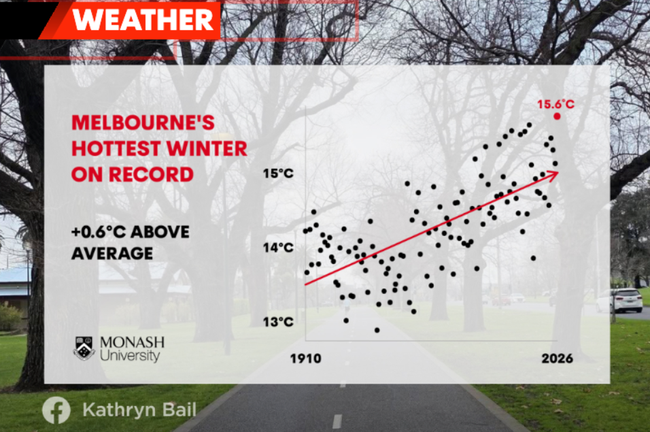
Melbourne has just recorded its warmest winter on record, with significantly above average temperatures both day and night.
But it hasn’t been dry — and that’s where the story gets interesting.
Know the news with the 7NEWS app: Download today

Melbourne recorded 66mm of rain in August, against an average of 50mm — comfortably ahead. The state-wide picture is far more uneven, though.
Much of northern Victoria finished above average and parts of the northwest recorded more than double their August mean.
That hasn’t come from frequent rainfall, instead coming from a small number of significant systems that happened to take a path straight through the region.
Meanwhile, parts of the south and the southwest Wimmera had a considerably below average August, simply because they weren’t in the path of those systems.
Same month, same state, same climate drivers — wildly different outcomes depending on where the systems tracked.

Across winter as a whole, much of the state finished above average despite the developing El Niño. The exception was eastern Gippsland, where there were no major low pressure systems off the coast — and that’s where Gippsland sees its most significant rain.

The rain has stopped, but the flooding hasn’t
Three rivers remain in minor flood on Tuesday afternoon, a full week after yet another significant rain system tracked across much the same parts of Victoria as the last one.
The Bureau reported moderate to locally heavy rainfall across much of northeastern Victoria and areas near the ranges early last week, driving creek and river level rises in the north of the state.
There’s been no significant rainfall since, and nothing major expected for the rest of this week, so those rivers have a chance to keep falling.
But here’s the thing about flooding — it doesn’t end when the rain does.
The minor flood warnings from the previous rain system were still current right up until the last one arrived. A full week on, and we still have minor flooding. Catchments this saturated take a long time to drain, and every warning that lingers is a sign the ground has nowhere left to put the water.
It also means the next significant system, whenever it comes, begins with a head start. The soil is already full. And the next major rainfall system may arrive as early as next week.
Safety advice
- Don’t drive, walk, swim or play in floodwater — it is dangerous.
- Stay away from flooded drains, rivers, streams and waterways.
- Obey road closure signs, and plan ahead so you don’t drive on flooded roads.
So how is this happening in an El Niño year?
It’s the question I keep getting, and it’s a fair one. We are firmly in a strong El Niño, and it’s expected to keep strengthening through the rest of the year. That encourages drier than average conditions here — but El Niño is not the be all and end all.
What it really means is less moisture is available from the Pacific Ocean to feed our weather systems. But the Pacific isn’t our only source.
Many of the waters around Australia are warmer than average right now — and have been for a long time — and they’re providing plenty of moisture of their own.
When a weather system links up with that moisture, anyone in its path can see significant rain, El Niño or not.

There’s more to it, too. Other major climate drivers, like the Indian Ocean Dipole and the Southern Annular Mode, are currently encouraging both moisture and weather systems to increase over Australia. Climate drivers don’t operate in isolation, and when they pull in opposite directions, the outcome isn’t as simple as the El Niño headline suggests.
We’ll keep you across the river levels and the next system as it develops.


